
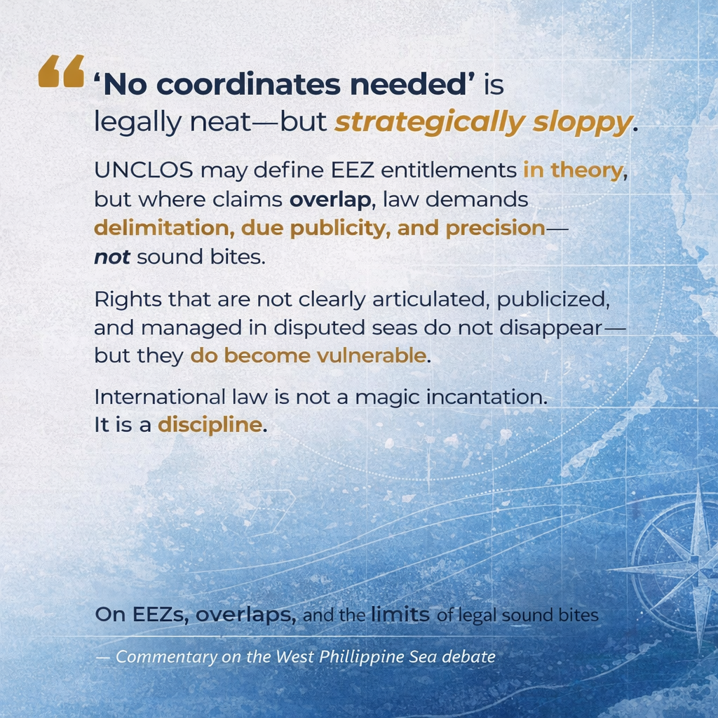
Justice Carpio’s sound bite, “UNCLOS already provides the EEZ (exclusive economic zone) limits; no coordinates needed,” as a response or critique against Sen. Rodante Marcoleta, is the kind of statement that is technically defensible in the abstract but STRATEGICALLY SLOPPY AND LEGALLY INCOMPLETE in the Philippine setting.
Yes, you can compute a 200-nautical-mile belt from lawful baselines. But once you move from classroom geometry to REAL DISPUTES WITH REAL NEIGHBORS, the law stops being a one-liner and starts requiring DELIMITATION, DUE PUBLICITY, and DISPUTE-MANAGEMENT.
Let’s unpack the “correct but incomplete” parts and why oversimplifying them is not just annoying; it can be harmful to the Philippines’ claims in the South China Sea Dispute (SCS).
1) Carpio’s “ipso facto” argument: He’s mixing Continental Shelf Doctrine into the EEZ:
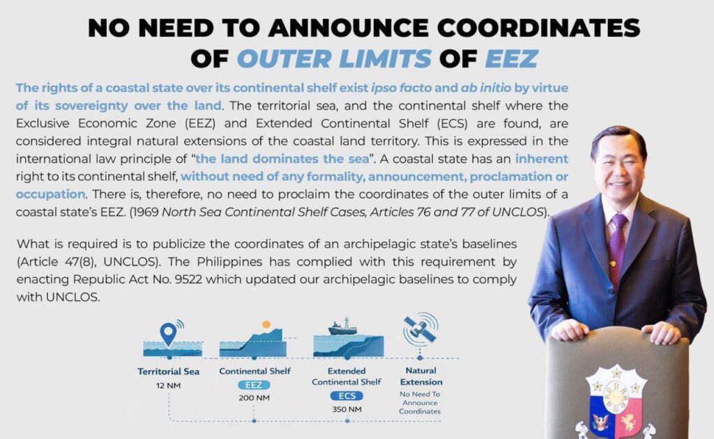
Carpio’s poster-style claim leans on the classic continental shelf doctrine: that shelf rights exist ipso facto and ab initio, by virtue of sovereignty over land, without proclamation. That’s a real principle in international law, rooted in the ICJ’s North Sea Continental Shelf jurisprudence and reflected in UNCLOS for the continental shelf regime.
But here’s the problem: Continental Shelf ≠ EEZ. For the continental shelf, UNCLOS recognizes that coastal State rights do not depend on occupation or express proclamation (the “ipso facto/ab initio” logic). For the EEZ, UNCLOS treats it as a distinct zone (Part V) with a defined legal regime (sovereign rights over resources, certain jurisdictional competences).
So when Carpio speaks as if EEZ coordinates are irrelevant because “international law already provides” the limits, he is smearing together two regimes. It’s rhetorically convenient, because it sounds like magic, but it’s DOCTRINALLY IMPRECISE.
Meaning, the continental shelf has an “automatic” quality; the EEZ is a legal zone you must articulate, especially vis-à-vis other states.
2) The Fatal Missing Clause: Overlaps Trigger Articles 74 and 75: Carpio’s statement is most defensible for a coastal State with NO OVERLAPPING CLAIMS, a rare unicorn in the so-called “West Philippine Sea (WPS) neighborhood.
In the Philippines’ case, OVERLAPS ARE THE RULE, NOT THE EXCEPTION! And when EEZ claims overlap, UNCLOS explicitly turns on Article 74:
- Article 74(1): delimitation between States with opposite/adjacent coasts “shall be effected by agreement… to achieve an equitable solution.”
- Article 74(3): pending agreement, States “shall make every effort” to enter provisional arrangements and “not jeopardize or hamper” the final delimitation.
That means: in overlap zones, entitlement exists, but EXCLUSIVITY DOES NOT until delimitation (or a workable provisional arrangement). The law is designed precisely to prevent the “I drew a circle on a map, therefore you must obey me” approach.
Then comes Article 75 (the part Carpio’s sound bite effectively airbrushes out): Outer limit lines of the EEZ shall be shown on charts or coordinate lists, and a copy shall be deposited with the UN Secretary-General.
So while UNCLOS doesn’t say “you must publish coordinates in order for an EEZ to exist,” it absolutely contemplates due publicity and deposit, because law is not only about having a right; it’s also about MAKING THAT RIGHT KNOWABLE and ADMINISTRABLE!
Carpio is “legally right” only in the narrowest sense (existence of entitlement). HE BECOMES MISLEADING when he implies that coordinates are legally irrelevant in a region of overlaps and disputes. They’re NOT irrelevant, they’re part of the legal hygiene of claims-making.
3) Carpio’s critique of Sen. Marcoleta swings too far in the other direction: “no coordinates needed.” That’s the classic “gotcha” move: he wins the sound bite, loses the policy. In disputed and overlapping areas, coordinates and charts matter for at least five reasons:
- Due publicity (UNCLOS Art. 75), so your claimed limits are knowable and consistently used.
- Enforcement clarity (for fisheries, environment, energy, law enforcement).
- Diplomatic posture (clear claims reduce accidental escalation).
- Litigation preparedness (future arbitration/negotiation needs clean cartographic records).
- Avoiding self-inflicted confusion (mixed messaging across agencies is strategic malpractice).
So yes: you can compute without coordinates. But no: you CANNOT GOVERN, DEFEND, NEGOTIATE, and ENFORCE CREDIBLY WITHOUT A CLEAR PUBLISHED CLAIM ARCHITECTURE. That’s the grown-up version. Everything else is INFOTAINMENT!
- The irony here isn’t just rich, it’s borderline theatrical: Justice Carpio himself was the ponente in Magallona v. Ermita (G.R. No. 187167), and that very decision contains a crystal-clear statement: UNCLOS is not about acquiring or losing territory. It regulates sea-use rights over maritime zones measured from baselines. Period. In other words, applying UNCLOS baselines is not “giving away land.” Territorial sovereignty rests on entirely different legal foundations.
So far, so good. Textbook law. No controversy. Now comes the inconvenient part.
That same decision, written by Justice Carpio himself, explicitly DETACHED Philippine territorial seas from the “treaty limits” established under the THREE HISTORIC THREATIES inherited from the United States, in favor of the 200-nautical-mile EEZ framework. The result??? What was affected was not some random area of roughly 830,000 square kilometers of what had previously been treated as part of the territorial sea under the treaty-based framework.
The three historic treaties that define the Philippines’ treaty limits, all inherited from the United States when sovereignty was transferred to the Philippines, are as follows:
1. Treaty of Paris (1898)
- Parties: Spain and the United States
- What it did: Spain ceded the Philippines to the U.S. after the Spanish-American War.
- Why it matters:
- It explicitly defined the territorial boundaries of the Philippines using coordinates.
- This is the first international legal instrument that delimited the Philippine territory as a unit under international law.
2. Treaty of Washington (1900)
- Parties: Spain and the United States
- What it did: Spain ceded additional islands (not clearly included in the 1898 Treaty of Paris), including islands in the Sulu Sea and surrounding areas.
- Why it matters:
- It clarified and completed the territorial scope of the Philippines.
- It cured ambiguities left by the 1898 treaty.
3. Anglo-American Convention (1930)
- Parties: United States and Great Britain
- What it did: Defined the boundary between the Philippines and North Borneo (now Sabah, Malaysia).
- Why it matters:
- It confirmed the Philippine territorial boundaries vis-à-vis another colonial power.
- Reinforced the Philippines’ international personality and territorial extent prior to independence.
Why do these three matter? These treaties are the legal backbone of the Philippines’ treaty-based territorial limits, which were later incorporated into Philippine constitutional law. This is precisely what G.R. No. 187167 (Magallona v. Ermita) reinterpreted when it decoupled territorial seas from treaty limits in favor of UNCLOS maritime zones.
Moreover, PD 1596 (during Marcos Sr’s time) asserted sovereignty. Magallona v. Ermita reframed sovereignty as “separate” from baselines. Legally neat? Yes.
Strategically costly? Arguably, YES, because it weakened the territorial framing of Philippine claims in the South China Sea and pushed them into a purely UNCLOS-based maritime rights box.
And this is where today’s irony kicks in: The same retired justice who now lectures about UNCLOS “not causing territorial loss” authored the decision that neutered the practical force of Marcos Sr.’s PD 1596.
So let’s pause and ask the obvious, uncomfortable question:
👉 If Philippine claims in the South China Sea were “weakened,” whose doctrinal pen did the weakening?
👉 If treaty limits were sidelined, whose jurisprudence did the sidelining?
👉 And if all this happened under G.R. 187167… sino nga ulit ang ponente?
Exactly! Which makes today’s performance rather… bida-bida, don’t you think?
And when he pivots to selling “no coordinates needed” as if that were the whole story, that’s not legal clarity, that’s headline lawyering: compressing nuance until it fits a talking point, while hoping nobody remembers the footnotes… or the ponente. But the law, inconveniently, remembers.
You know what, folks, Carpio’s line is the legal equivalent of saying: “You don’t need street addresses because the city already has roads.” Cute, right? Technically true. Completely unhelpful when the dispute is who owns which house, where the property lines overlap, and someone is already camped on your front yard.
International law is not just about having rights. It is also about stating them precisely, publicizing them properly, and managing overlaps without self-sabotage if the Philippines wants to win this claiming game in the SCS dispute. Duh!
Core sources used
- UNCLOS (Part V—EEZ; Part VI—Continental Shelf; Arts. 74, 75, 77).
- Administrative Order No. 29 (2012), Sections 1–2.
- Magallona v. Ermita, G.R. No. 187167 (Carpio, J.).
- South China Sea Arbitration (jurisdiction award discussion on sovereignty limits).
- ICJ North Sea Continental Shelf (continental shelf ipso facto/ab initio doctrine